Planned work program:
Program will have three pathways – all running at the same time.
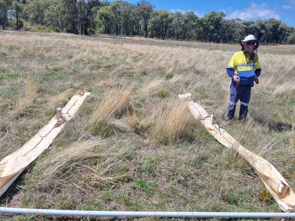
- Ground penetrating RADAR program.
- Survey across anticipated extensions of known paleochannel intercepts.
- Extend that survey with analysis of graphic results – see graphic.
- Radar survey hard rock potential ore bodies – again that extend into 1065.
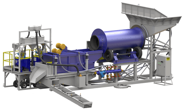
- Professional metal detector survey – locating close to surface concentrations of gold – numerous identified areas over 10 km strike – followed by radar surveys then auger drilling, bulk testing with PGL processing plant. Consideration high tonnage bulk close to surface mining – potentially utilising mechanised roadwork type scrapers.
- Utilising latest technology metal detectors to find concentrations of small nuggets that can signify an ore body hidden by alluvial cover, followed by close grid radar survey to direct PGL drill rig targets and assay results.
- Intense study of all results and how they impact the overall selection of new targets.
- Ground proof, plot hard rock targets – radar survey at earliest.
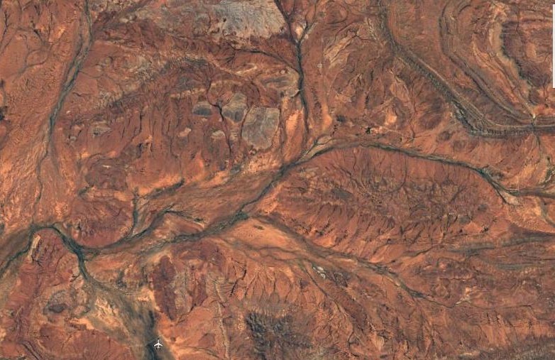
First radar survey plotted – attempt to intercept recorded high-grade paleochannel.
Priority Targets.
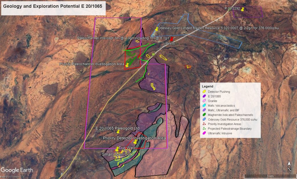
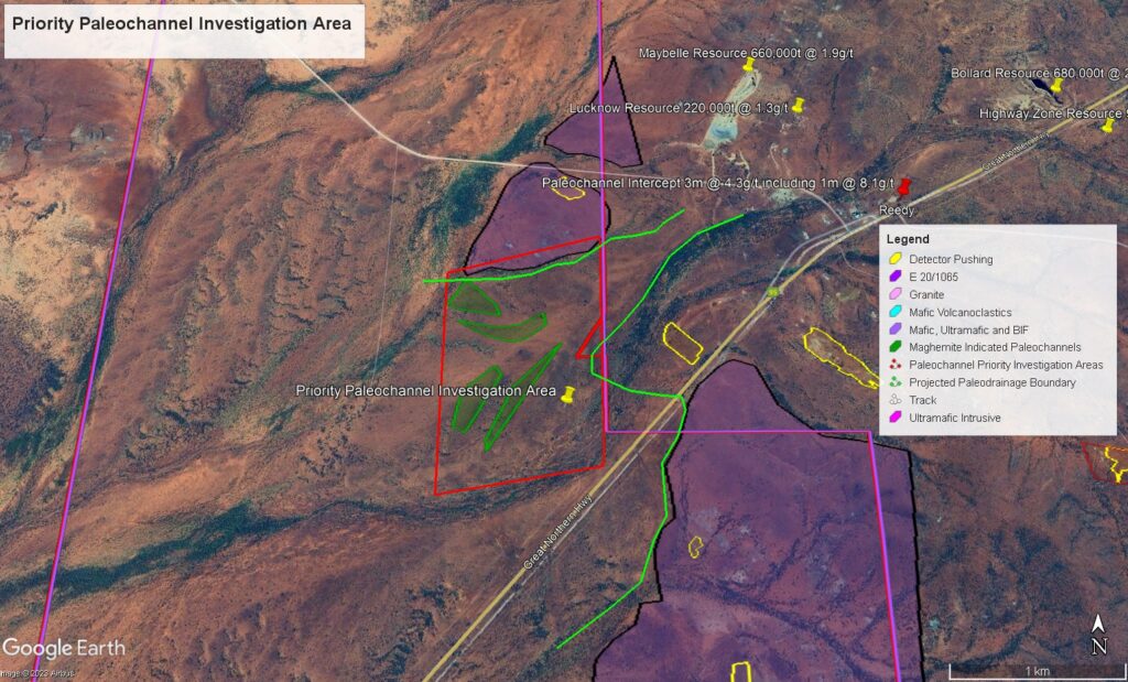
In the north a significant ovoid shape granite dome lies within the tenure and immediately south of the Tuckanarra Gold centre. The contact between the granite and surrounding greenstone is sheared and is considered prospective for gold mineralisation. Acquisition of geological and magnetic data has highlighted the position of the contact. Acquired processed magnetics have highlighted potential paleo-drainages within the top portion of the tenure.
Note: Significant potential for paleochannel deposits downstream of Tuckanarra – Reedy’s goldfield. Note drill hole upstream of 20/1065 that showed 4m @ around 4g/t with 1m @8g/t. 1.8km from our boundary.
Review of exploration on neighbouring tenements E20/783, P20/2417 and P20/2418 (acquired data and Open File) has highlighted the potential for gold in paleo-drainages. The main drainage system that drains the Tuckanarra Gold Mining centre passes onto E20/1065. Detail airborne magnetics (unfiltered) has outlined a series of old paleo-drainages (not a part of the current drainage system) by enhancing maghemite which is inferred to be within the paleo channels. The targets are up 700m long and may represent auriferous paleo-drainages. Paleo-drainage Targets.
Location: Our new Tuckanarra Project lies 30km NNE of the town of Cue in the Murchison Goldfield. E20/1065 straddles the Great Northern Highway and lies immediately south of the historic gold mining centre of Tuckanarra.

The new Tuckanarra Project is considered very prospective for gold mineralisation. Large areas of detector pushing on Mafic volcanics to south of the licence lease. This structural rock unit extends into E 20/1065 and must also be prospective for gold using detectors to plot gold concentrations followed by radar to pinpoint targets, all enabling potential bulk processing of any commercial concentrations.
Note – the zone within our licence has not been treated and potentially the source of the gold in the very large detector mechanised pushing area on the neighbouring tenement to the south. – a priority target.
In addition, this same southern section of 20/1065 there is potential for small high grade paleochannels draining from these Mafic volcanics.
The potential exists for hard rock ore bodies on the northeast of the EL where small historical mines can be seen on Google.
All the above are priority targets.
Chiltern Victoria Update.
September 2023
Radar start at Scothmans Lead Chiltern.
Our Chiltern Victoria project covering the highly prospective Scotchman’s Lead area continues. Next steps will, on Vic Mines Dept. approval, involve selected excavation of costeans to open up several sections of the leads to study the potential for gold recovery left behind by the early miners. This can include unmined areas between claims, offshoot small leads, and potentially unmined leads unknown until the radar revealed their presence.
The Chiltern goldfield was extremely rich and historically produced some 27 tons of gold – all in a short time period. It was known at the time as the New Ballarat.
Indeed a very important target for the company. We continue to review this project prior to entering into a JV for the next phase.
The following are excerpts from our Consultant Geologist, Derek Reeves report.
The Chiltern goldfield was a phenomenally rich deep lead field – essentially alluvial gold in deep buried rivers. So rich it was known as the New Ballarat. We will target the shallow feeder channels that deposited that gold.
Over 500,000 ounces (reported) was produced from a small area – all essentially alluvial gold.
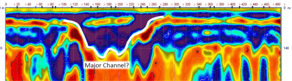
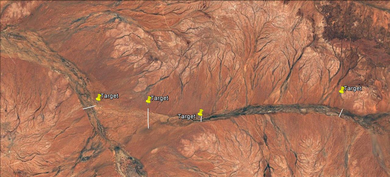
A typical radar image.
We have targeted the tributaries that fed these rich deep leads – the source of the gold that made this historic field so famous. We can see via radar very shallow paleochannels that have remained undiscovered until now – with our technology we have located these ancient channels ready for the next step opening up the targets via excavation – shallow depths.
![]()
Early miners and explorers had no possible way of locating these gold source channels – now we can do this simply and easily – modern science at work with newly developed next-generation ground penetrating RADAR coupled with state of the art computer modelling gives us the “drill here” accuracy we expect.
This is an exciting new development for the company
Victoria was historically the richest alluvial gold region in the world.
And potentially still carries significant reserves.
Victoria’s alluvial gold made history with discoveries such as Ballarat and Bendigo and Victoria is now is seeing a very successful revival in deeper hard rock exploration deposits which were not known to earlier explorers – new technology has changed that. Deep deposits in new areas are numerous and will keep coming. These are hard rock deposits.
Where you have hard rock deposits there will be alluvial deposition not far away – formed by weathering and erosion of this primary gold mineralisation.
This new gold boom in Victoria is opening up opportunities for our alluvial technology based exploration tools – and PGL will now be part of it. The hard rock explorers are not interested in what we are interested in – all to our advantage.
We see great opportunity in bringing our technology and methodology to Victoria – not just for a focus on the new areas and what that can hold for alluvial gold in paleochannels but most importantly looking at the shallow channels missed by earlier miners. And our Chiltern licence will be the first.
Remember that old goldrushes finished either with a lack of easy gold or a low gold price which stopped many projects in their tracks. This latter cause leaves many untouched areas in Victoria in the one of the world’s greatest alluvial provinces. A no-brainer for a shallow paleochannel explorer -and we are just that and with an exclusive proven technology – methodology.
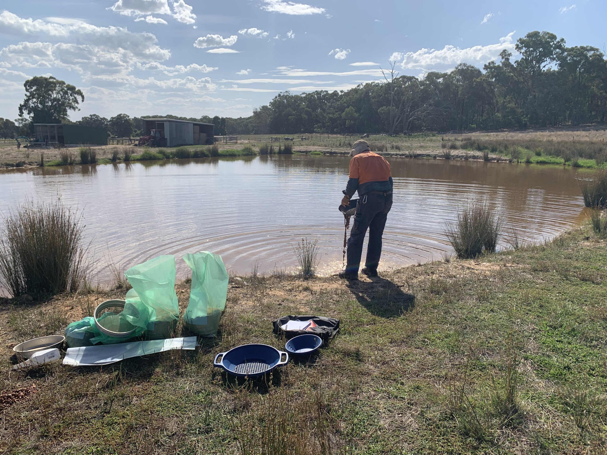
Washing the drill samples at Chiltern.
We know Victoria very well having mined alluvials and shallow paleochannels successfully in the 90’s only ceasing because of the very low gold prices at the time. Not like now with such high gold prices projected to continue for some years.
There are numerous locations in our study area and Chiltern is a first for the Victorian portfolio. Located in an historic ultra-rich deep lead location in an historic goldfield the tenements we are targeting have mostly never been explored for shallow channels.
Great Fingal South Project
We have applied for and have received approval for six POW’s (Program of Works) over six tenements on the outskirts of Cue township that are well known for surface nuggets. Work can commence immediately. POW’s are valid until mid-2027.
The planned program is to utilise dry blowing gold recovery to identify “hot spots” that may be signalling concentrations under cover.
To that end we have an agreement with a local dry blowing expert whose business is full time dry blowing for gold. He has substantial equipment and has been successful for a number of years in the Cue area. His is a large scale high throughput operation.
He is very keen on the areas we have planned and in his words, knows there is surface gold in numerous locations on the tenements.
Our agreement is for a share of gold production plus full GPS reporting of daily recoveries. These locations will be plotted to gradually build a picture of where the gold is, and any concentrations.
Our consultant geologist utilises this technique in some circumstances prior to any radar survey.
We are confident that this project can go some way to solving the puzzle of gold concentrations around Cue and potentially provide some modest gold production.
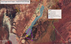
Overview of the Great Fingal South Project Tenement showing Projected Paleo-drainage downstream of Major Historic Mines and Modern Open Cuts.
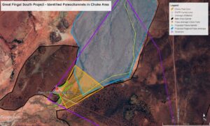
Detail of the Great Fingal South Project showing the DGPR Survey Lines, Projected Paleochannels and the Choke Point.
Paleogold have signed agreements with the tenement holder for complete control & access at our option and control of all alluvial & paleochannel gold recovered.